WILLIAM BARROW KENDALL (1851-1919)
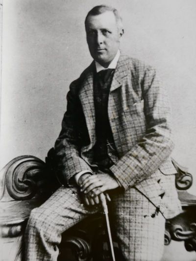
Thanks to Barrow Archives for the photograph and access to his records.
W.B.Kendall was born in Salthouse, Barrow-in-Furness. He attended Town Bank Grammar School, Ulverston, then trained to be an engineer for Furness railway. William was a member of Barrow Naturalists' Field Club and a keen antiquarian. He conducted a number of important studies and gave talks to the Club, some of which were published in Furness Lore, a series of books containing 'Transactions of the Barrow Naturalists' Field Club.' He was a prolific writer and important early historian researching many aspects of Furness. producing works on 'Cocken: The History of a Furness Village', 'Northscale', 'Gleaston Castle', 'Notes on the Village of Barrow', 'Waste of Coast Line, Furness and Walney in 1000 Years', and 'Muchland and its Owners.' He moved to London in 1895, where he had access to the Public Records Office and was able to continue his historical research. His 14 Notebooks, held at Barrow Archives, contain notes taken primarily from records he accessed at the Public Records Office. He was the oldest of ten children, at least three of whom (all girls) died in infancy. He did not marry. He died in Londonderry and was living with his brother and his family at the time - his brother Thomas was the beneficiary of his will. He is buried along with his brother Thomas in Derry City cemetery. One of his many lectures held at Barrow Archive is called Furness, and the Civil War between King and Parliament. The History Society are preparing this lecture for publication in the near future having kindly been given permission by Stuart Kendall. William Barrow Kendall is his Great Granduncle on his father's side, he is related through Thomas with whom William shares a grave. We hope to publish it during summer 2026. Millom and District Local History Society have now published the booklet which can be purchased, £5 from Sutton's Bookshop, Ulverston. Published Articles Gleaston Castle, W.B. Kendall, (read at Gleaston, June 30th 1905) CWAAS Transaction (1906) Vol 6. He is referenced in the following articles by Paul V. Kelly in CWAAS Transactions: Aldingham Motte and Grange, Paul V. Kelly (1924) Vol 24, PP. 271 - 277 Muchland and its Owners and Newbarns, Paul V. Kelly, (1924), Vol 24 PP. 260 - 270 The Barrow Naturalists' Field Club, J. Melville & J.L. Hobbs, CWAAS Transactions, 1949 Vol 49. Describes the foundation of the club and lists the contents of their Transactions and Proceedings. Here are the articles by W.B. Kendall, published in the BNFC Transactions: Cocken: The History of a Furness Village, (16 November 1896) Vol. XII, P 36 The Conventual Buildings OF Furness Abbey, (26 May 1882) Vol. IV, P13 Muchland Manor Court Rolls, Vol. XX, P86 26 November 1880 Prehistoric Remains Found in Low Furness, Vol. XI. P96 Gleaston Castle, (23 August 1902), Vol. XVII, P67 Muchland and its Owners, (20 January 1908 and 24 December 1908). Vol. XIX P59 Northscale, the History of a Furness Village, (21 March 1898), Vol. XIII P44 Salthouse, History of the Hamlet of, N.S. Vol. VI P21 Walney, Waste of Coast Line in 1000 Years, (23 July 1904) XVIII P75 The Village of Barrow, in the Parish of Dalton-in-Furness: Owners and Occupiers in 1843, Barrow Naturalists Field Club and Literary and Scientific Association Annual Report and Proceedings. Vol. 17 The Moot Hill, Aldingham Barrow Naturalists Field Club Proceedings. Trans Vol. 3 p119-120 Submerged Peat Mosses, Forest Remains and Post-Glacial Deposits in Barrow Harbour, Trans Vol. 3 p55-62. 26 November 1880 Archaeology Discovery in Chapel Meadow, Park, Dalton-in-Furness, with a note of two bronze keys and analysis of water from the 'holy well', Gaythorpe H and Kendall W.B. Trans Vol. 3 p37-40 These can all be accessed at Barrow Local Studies Library, Barrow Library, Ramsden Square, Barrow-in-Furness, LA14 1LL. Unfortunately, they have not been digitised (apart from the ones on CWAAS Transactions. These can be accessed via their website, Cumbria Past (see links at bottom of front page of our website). Whilst searching the various records at Barrow Archive, we came across this article from Barrow News, 13th August 1898 - as it is out of copyright we are able to publish it below. Harper Gaythorpe (1850 - 1909), was a local historian, engraver and amateur archaeologist who worked closely with W.J. Kendall on several projects. AMONG THE CUMBERLAND FELLS, A VISIT TO THE GREEN, CRAG HALL, THE MEGALITHIC REMAINS AT SWINSIDE, AND FENWICK, BY VIATORES (H. GAYTHORPE AND JOSEPH KENDALL, VETERINARY SURGEON, BARROW). A ramble on the Cumberland fells, "far removed from noise and smoke," on August Bank Holiday, afforded us a pleasant loop hole of retreat from which to gaze at a distance towards the busy town of Barrow-in-Furness. Taking advantage, like great numbers of other holiday seekers, of the Furness Railway Company's cheap fares, we made an early start for Green-road station, via Foxfield. It is not at all singular how so many are attracted, during the holiday season, by the sea trips to the Isle of Man, Morecambe and Blackpool, for "the sea, the sea, the open sea," will always have a charm and delight for young and old; and the excellent accommodation on the Barrow-built steamers leaves nothing to be desired for those who dare to "go down to the sea in ships"; but to our mind such holiday resorts as those named, with their crowds, are anything but pleasant, compared with the breezy fell sides overlooking the "Cerulean Duddon." For us, the upland pastures, the bloom of the bays and hills, and the wealth and variety of scene among the fells and mountains of our glorious Lake country have a charm far exceeding that afforded by the "ever-changing and mysterious sea"; for there we are brought more in touch with the "mighty mother of mankind." Leaving Barrow Central at 8-25, anon we arrive at Askam, passing on our way to St. Helen's about which so little is known, and the Holy Well at Park, and shortly after note at the line side the iron columns and other material which were to have been used in the construction of the proposed embankment and viaduct of the Whitehaven and Furness Junction Railway across the Duddon in 1865, the cutting of the sand bank towards the shore being also visible. The view from the train across the sands towards White Combe and Black Combe, with Millom Park in shade and the Whicham Valley in sunlight, and fleecy clouds on the mountain side, leaving the outline of Black Combe and the cairn on the top just visible was a picture beauteous to behold. On the shore near Dunnerholme and almost in view from Foxfield were the remains of a pier formerly used for loading small craft bringing cargoes to and from the Duddon, and several posts or piles, attached to which iron mooring rings have been found; but the course of the channel is now changed, and much land has formed on the west side. This pier was formerly used for the shipment of slate from Kirkby, but whether for iron from the blast furnace at Duddon bridge, "which was built early in the 17th century by an ironmaster named Jackson," or whether "the iron made at Duddon Furnace was shipped exclusively at the ancient Millom harbour, Borwick Rails" (or "Barrick Railes") we cannot say. "A pig of iron branded D.1781 was found at Borwick Rails, Millom, in 1866, doing duty as a lintel or bearer for an over-hanging chimney stack on an old farmhouse there." Probably to this old pier came the boat-load of soil brought over from Ireland by a former owner of Frith Hall, who, hearing that there were no snakes in Ireland, had the Irish soil distributed about his grounds in order to get quit of the Hagg worms which were very numerous there. Whether the application of this Irish soil proved a remedy or not cannot be stated. Leaving Foxfield, we cross the viaduct, and are soon at Green-road station. On the right is a most picturesque view of Coniston Old Man, to the north-east Dow Crags, White Pike, and in the distance Harter Fell. Crossing Black Beck we follow its course for about three quarters of a mile until The Green is reached, passing on our way the rural postman, that "messenger of grief perhaps to thousands, and of joy to some," as was evidenced by the expression of one lady whom we saw reading a just-opened letter at her cottage door. Looking in at the village shoemaker's shop, where trade is evidently good, for from ceiling and walls were hung lasts without end, and four men hard at work, one with "the lapstone on his knee," and instead of "hand-sewn" shoes being out of date we were surprised to learn that 19 work-men were now employed at one place in the Isle of Man in that industry. The cottages at The Green, covered with Virginia creeper and clematis and tea roses in full bloom, looked very beautiful. Further on at the door of another cottage was a large rosemary bush, "'that's for remembrance," which is also said to flourish only where the woman is the master. On each side of the gateway of another cottage were two yew trees trained and arched overhead. Proceeding on our way, we passed a gravel cutting in the drift, having its stratified layers well marked, and showing the deposition 15ft, or 20 feet from the surface. Interspersed in the drift were innumerable boulders, some of enormous size, mostly volcanic ash, porphyry and granite. At the Green the maypole - if it ever existed there - had given place to a finger post, and hard by we could hear the sound of the over-shot wheel at the Arnaby corn mill. Approaching "The Oaks" - rightly named, for the monarchs of the forest are very remarkable specimens, one near the road being at least 3ft. in diameter, and horse-chestnut, ash, beech, and sycamore trees being also plentiful. A peep through the gate revealed a charming view from the lawn across the valley to Hallthwaites Wood. Passing Hallthwaites with its bleaching mills and dyeing houses we had a view of Kirkby Moor and Woodland Fells on the right, and a glimpse of Foxfield Station and the Duddon, and in the distance Red Screes and the fells above Ambleside. The modern Gothic Church of St Anne at Thwaites, and the schools are now at hand. The old chapel was built at the expense of the inhabitants, A.D. 1715. The present church was erected in the year 1853-4 on a site given by William Postlethwaite, then owner of "The Oaks," who emigrated to New Zealand, where he owns large estates, and is at present in California, fruit growing. About eight or nine years ago an organ was obtained for the church, towards the cost of which the present Mr. Lewthwaite, of Broadgate, subscribed £100, and Mr. Myers, of Danningwell, and other wealthy families also subscribed liberally. The sun dial in the churchyard has no motto, not even "Tempus Fugit," but is dated A.D. 1838. On the south side of the church is a magnificent rose tree, in full bloom with large clusters of white flowers, while close to the building are raspberry trees in fruit, and in the outer walls grow the asplenium, rue, and polypodium ferns. In the churchyard are the tombs of William Lewthwaite, of Broadgate, who died 1867, and Joseph Lewthwaite, of Kelstern, Lincolnshire, who died 1886. In this connection the family motto is most appropriate - "Virtue tending towards Heaven." Proceeding on our way we pass Bank House, and westward in the distance the spires of Chappels were visible. On the roadside a small, but carefully placed heap of stones recalled with a smile the humorous story of "Joe and the Geologist," and its supplement "Trees on't." All along the way the summer flowers were in great profusion, the trailing honeysuckle, the harebell, knapweed, elderberry, hawkweed, purple and yellow vetches, yellow poppies, fox glove, and meadow sweet; and we noticed that here as on Walney and other places in Low Furness the trees in the hedge rows incline to the east, not because of the westerly winds, but quite as much the result of the leaf buds surviving on the eastern side. Higher up at the junction of the roads to Broughton and Broadgate the view opens out, and we now see the Duddon at high water, Askam, Millom and Barrow Iron Works, Walney Island and Channel, and in the distance the Irish Sea. The Duddon has a speciality in cockles, which are reputed the best and finest of any in the north country, Sandford (about 1675) speaks of the Duddon as "a brave river where the famousest cockles of all England is gathered in the sands, scraped out with hooks like sickles, and brave salmons and flooks, the bravest in England, hung up and dried like bacon." Passing Thwaites Corn Mill and the Spanish chestnuts and other forest trees surrounding Broadgate we soon reach Crag Hall, built as its name indicates beside a crag of Skiddaw Slate. Here we made enquiries about a second stone circle, the various accounts of which in local histories are so conflicting, and our endeavours to trace its position and get at the facts relating to it were almost as difficult as squaring the circle. We had read the accounts in Gough's Camden, Hutchinson, and Mrs. Lynn Linton quoted in volume v. of the Transactions of the Cumberland and Westmorland Antiquarian and Archaeological Society, pages 49, 50, perhaps the most difficult to understand being that of Hutchinson and which is still further complicated by the word north in line five, page 49 being printed instead of south. The most correct account we have seen is in Jollie's Cumberland Guide and Directory (1811), part 11, page 39, extracted from Housman, page 472. "Not far from this (Swinside), we see a second circle of stones situated on a rising ground, which is dry, and seems to have been levelled for the purpose. An opening towards the southwest affords a view of Duddon Sands. This, though a more pleasing situation appears to have had less attention paid to it. The stones are small and few in number, only 22 appearing above the surface." The only exception to be taken to this account is the word south-west as the Duddon Sands cannot be seen from the south-west, the view on the west side of Knott Hill being towards Whicham Valley and the sea, and no rising ground apparently levelled for the purpose is anywhere to be seen on the south-west side of Knott Moor, while there is on the south-east side. We had heard from a former resident in the neighbourhood that very many years ago during Mr. Lewthwaite's absences abroad, the second circle was near Crag Hall, and that the stones were removed by a farmer, and used in making a barn. He was also going to remove the stones at Swinside, but Mr. Lewthwaite returned home in time to stop him. The barn at Crag Hall was built about 1829 or 1830, but neither Thomas or Margaret Garnett who live there (the latter being born in 1819), recollect anything of this removal. On examining the foundations of the barn we found some fairly large stones about two to three feet long, and in the cart house adjoining, a stone about four feet long, with a bore hole showing it had been blasted. Leaving Crag Hall we examined the enclosures on the rising ground to the left, both on our way to Swinside, and on our return, and came to the conclusion that the second circle had been either in the enclosure now known at New Close adjoining the Knott plantation on the south side, or the enclosure called Little Leys to the north of New Close, and adjoining Limekiln Field, preference being given to the former on account of its answering to the description given by Houseman, and also having 15 stones about three feet high, all within a small radius and close together, but not now in a circle, there being also a number of other stones and thorn trees in the field. The enclosure called Little Leys, also answers the description, and it has a small well near the centre. At the entrance from Limekiln Field are two halves of a stone of immense size, the larger half seven feet six inches by three feet six inches, and the smaller five feet by three feet six inches, the bore hold where they have been blasted being 11 inches deep. From both of these enclosures there is a view of the Duddon Sands. Formerly there existed in Dam-head meadow, which adjoins Cockstone meadow, and is situated to the S.E. of Barnett's wood or Knott plantation, on the Crag Hall estate, a large stone about 5ft. high, set upright and sunk about 2ft. into the ground. This stone was in a direct line with one in Low Meadow at Thwaite Yeat occupied by Robert Troughton, and another in the Oaks meadow close to "The Oaks," both similar in size to the one first named; but they have been blasted and removed. It is considered they were formerly used as boundary marks or guide stones. The old road from Lady Hall comes up to Gornal ground, and we traced it from the former place to Hazel Mount. It is said to be traceable to Keswick. Another old road can be traced from near Duddon Bridge past Mrs. Robinson's at High Duddon through Duddon Wood and close up to Barrow (now destroyed) and traces are still in existence to Stoneside. Beyond Crag Hall on our way to Swinside and adjoining Little Leys is an enclosure called Great Leys, a large stone in which, about 7ft. by 3ft. 6ins., has a curious history. We heard it had been carried from the circle at Swinside by an old woman in her apron, but the string breaking with the enormous weight accounts for the stone being deposited near a well by the roadside. A very similar story is told about an enormous boulder called Carl Crag on the seashore to the north-west of Drigg. It appears that his Satanic Majesty once took it into his head to unite the Isle of Man to England by means of a bridge, and attempted to convey this huge mass as a foundation stone, but his apron string broke, and the enterprise was abandoned. Proceeding over the moorland the stone circle at Swinside and the farmhouse are now in view, and in imagination we see the "long procession gathering from the mountain caves and rude forest homes, as the white-robed priests and the holy maidens, oak-crowned and with torque and band of gold, marched slowly through the vale, leading the white bulls for sacrifice, and bearing the golden sickle and the unspotted cloth, while chanting their temple songs and striking their barbaric music." What a marvellous change is seen in our days! On this Bank Holiday Mr. Charles Norman's farm-servants are gathering in the hay, and inside the circle the mowing machine has left its traces in concentric rings; no sounds can be heard except those of the birds and the farming implements, and all around tells of peace and contentment. The enclosure in which the circle is situated has been known as Temple meadow for at least 60 years. The rowan tree is still in the cleft of one of the largest stones on the north side of the circle, but now lifeless. It began to decay during the very dry summer of Jubilee year - 1887. The height to the topmost bough is about 16ft. the stem at the top of the stone is 7in. thick, and about one foot in the stone it is 10in. thick, and irregularly shaped. It extends downwards in the cleft of the stone and the roots - still visible - spread out at the bottom to a width of 2ft. 6ins., but these and the trunk sound quite hollow when struck. The portion of the stone split off by the growth of the tree and other natural causes is 1ft. thick, and the stone is more or less cracked vertically in two other places. There is distinct evidence that the death of the tree has been primarily caused by names and initials having been cut and carved on the bark to such an extent as to prevent the up-rising of the sap, and it is very regrettable that not only the tree, but several of the stones forming the circle, have during this present year been mutilated by the Goths and Vandals who have visited these stones and rudely carved their names thereon with chisels, evidently taken with them for the purpose. The attention of the proper authorities is being called to these acts of wanton mischief, and it may interest the perpetrators and others to know that the names of eleven have been noted. The account of Swinside Circle as given in Gough's Camden, 1806, vol. 3, and the account of the smaller circle - variously stated to be "not far from Swinside," and "about a mile from there" have both been extracted by the author of the "Antiquities of West Cumberland and the Lake District" from Housman's Topographical Tour. The former is a very scarce book, and originally appeared in the form of articles in the "Kendal Mercury" about 1849. The author of this valuable little book - a sound antiquary - we have been unable to trace, though it has been thought to have been written either by Mr. Jackson, whose fine library is now at Tullie House, Carlisle, or by Dr. A.C. Gibson, the author of "The Old Man, or ravings and ramblings round Conistone." In Hutchinson's account, written in 1794, "the small but beautiful, druidical monument," which he describes as "circular and about 20 yards in diameter, the stones of which are from 6ft. to 8ft. high," has evidently been the one on the rising ground near Crag Hall and not at Swinside, for he adds, "a little to the north (Swinside) is another of larger dimensions, but not in so perfect a state." From Housman's account, written in 1800, it is evident that he saw the smaller circle, but as Jollie in 1811 copies this account word for word it is probable that he did not personally inspect it, and, judging from the account written in 1849, one would suppose the smaller circle was not then visible, so that the stones forming it must have been removed between 1800 and 1849, most probably when the enclosures were fenced in, which we learn was before 1821. Of the 55 stones which form the Swinside circle, 29 are now standing either erect or in a sloping position, and 26 have fallen down. It has been suggested that as the entrance to the Swinside Circle is towards the S.E., it might have been a Solsticial Temple similar to the earliest known Egyptian ones, which were used by sun worshippers at the winter solstice, but from calculations based on the data as given by Mr. C.W. Dymond in his valuable article on "Cumberland Megaliths" in vol. 5 of the Transactions of the Cumberland and Westmorland Antiquarian and Archaeological Society, it is found that when the sun rises over Kirkby Moor, near Out Park, about sixteen days before or after the winter Solstice it would appear to an observer at the centre of the Swinside circle to be framed in the entrance. The difference in alignment between a true Solsticial Temple and the one at Swinside would only be about three to four degrees for similar conditions of latitude, therefore we may assume that this difference of about three to four degrees was either a mistake of those who planned the circle, or else they used it after the winter Solstice has passed. On stepping the distance inside the circle we found it to be 29 yards from east to west, and 31 yards from north to south. On the eastern side there is a space of five yards where the stones have been entirely removed. The wild thyme and pink heather bells were growing in profusion on Knott Moor, but we never saw one busy bee. During our walk we noticed that birds were plentiful - the stonechat, swallow, pied wagtail, rook, curlew, yellow-hammer, and the blackbird, thrush, magpie, and hawk; and in the stone circle on our return we saw numbers of sea-gulls and starlings. From Swinside we went over the moorland to Mr. William Bowes, at Fenwick, a lonely farmhouse three miles from either church or school, passing on our way one field in which were great numbers of the plant called lady's mantle, that is, the mantle of "Our Lady," the Virgin Mary. At Fenwick we inspected two pre-historic implements, of the kind known as perforated stone axe hammers, which tell of the presence of man in this remote part during the Neolithic period. The view from Fenwick, about 900 feet above the sea level, is more extensive than from Swinside. The fells were covered with clouds, looking very grand, and while Corney Fell was bathed in sunlight, Black Combe and Bootle Fell were in shadow. On our return we varied the route, passing Mr. Wm. Postlethwaite's at Black-beck, and Thwaites mills, and having another view of Broad Gate from the Valley with Black Combe in the background, enveloped in clouds. In the opposite direction, towards Gornal ground, passing on the left Mr. Thos. Bowes', Greystone House, the view over Heathwaite and Woodland fells in deep shadow, and their sombre outlines clearly visible, was very striking. The old farmhouse at Gornal Ground has now given place to a modern erection, occupied by Mr. Hartley. The stone over the doorway was so old and coated with lime that the initials and date could not be traced. Passing by Hazel Mount we traversed the old paved road about 6ft. to 8ft. wide, walled on each side, and now much overgrown, which leads in the direction of Crag Hall and Swinside. At the hamlet of Lady Hall, we noticed in the front of one house I.E.H., 1755, and approaching Foxfield, examined the old farmhouse, with its dated stone T.A.H. 1697, just 201 years ago. The old building is now used as a playhouse by the children living near to, and uninhabited except by fantail pigeons. Arriving at Foxfield, as the train from Broughton and Coniston came into the station, the scene soon changed from one of quiet which had prevailed throughout the day, to one of bustle and noise. Many of our friends were there, some with the spoils of the chase, others with lovely flowers and ferns, and not a few "piscatorial assassins" who had been enticing the finny tribe; the greater number, especially the young couples, looking extremely happy. This attempt to trace a lost stone circle would be incomplete without a word of thanks to those whose very intimate knowledge of the surrounding district has enabled the writer to become a guide to others wishful to investigate the site of the circle for themselves. Especially are thanks due to one Thomas Garnett of Crag Hall who taught the school at Hallthwaites for eight years and who, although well qualified for the position of master, resigned when the school was taken over by the Millom School Board in 1878. It is a pleasure to state that many of his old boys are doing well in the world; among the rest are two solicitors, Mr. Henry Walker, formerly of Greystone House, Thwaites, and now practising near Rugby; and Mr. William James Robinson, of the Green and now of Bristol. Since the above was compiled, the writer learns that "there is a circular place in a field at Gornal ground adjoining the old "Roman road," which is thought to have "formerly been a Druidical resort, and there are a number of huge stones lying about the place." BARROW NATURALISTS' FIELD CLUB: GORNAL GROUND, H. GAYTHORPE, JULY 1903 At the seventh excursion for the present season fine weather and the prospect of a walk over new ground was sufficient to attract a good number of the various sections of the society. The ramble from Foxfield to Lady Hall afforded many charming views of the "Cerulean Duddon," and of the mountain scenery in the neighbourhood. Arriving at Lady Hall the hamlet was inspected, and the views across the river Duddon were much admired. The houses in the hamlet appear to have been built in the 18th century, one dated stone bearing the initials I.E.H. 1755. In company with Mr. and Mrs. J.W. Chadwick, the party then made a move for Gornal Ground, which is approached by an old paved road. This road, according to statements made by Mrs. Mary Steel, who lived at Lady Hall 50 years and died there recently aged 84, was formerly used by persons going to Whitehaven. Until the year 1902 it was thought by some to be a Roman road, but the investigations by Mr. C.W. Dymond, F.S.A. and Mr. W.G. Collingwood, M.A., have set at rest the idea of it having been more than a pack-horse track, which seems to have led from Furness by the Over-sands route via Green or Lady Hall to the old harbour of Ravenglass. Their investigations have also shown that at Gornal Ground, which adjoins the old road, the "second circle of stones" referred to by Houseman in his Topographical Description of Cumberland and Westmorland, 1800 p.472, is to be located. The writer of these notes, in 1898, made an attempt to discover the lost stone circle, but the indefinite nature of the descriptions of Hutchinson, Housman, and other writers, coupled with the suggestion that it was near Cragg Hall did not clear up the matter, but his notes afforded valuable aid in prompting and guiding others in their researches. After studying the results of Mr. Dymond's and Mr. Collinwood's investigations as printed in Vol. 2 (N.S.) of Transactions of the Cumberland and Westmorland Antiquarian and Archaeological Society, and examining the remains of the spot, it is evident that the ruins at Gornal Ground are those of a medieval village and not what Hutchinson and Housman in the wisdom of their day referred to as a small but beautiful Druidical monument or a second circle of stones situated on a rising ground, which is dry, and seems to have been levelled for the purpose. In Mr. Dymond's and Mr. Collinwood's investigations "a mound inside the circle at Gornal Ground was dug into, and burnt stones and soot, lumps of rusted iron, and scraps of charcoal, etc., were dug up. This seemed to point to some kind of smithy. The remains are evidently those of a station or an ancient way answering very much the same end as the principal way side inns in more settled districts. So far as is known the place would form in medieval times either a halting place between the 10 mile stage over the mountains to Waberthwaite or before attempting a tidal transit across the Duddon. The spot being well sheltered, and probably in medieval times provided with huts or sheds, carriers would there find accommodation for themselves and their wares while the village smithy would offer facilities for renewals of gear and horseshoes. The place is therefore a unique example of a medieval station of a peculiar type, and it is hard to imagine any other purpose than that for which the spot could have been inclosed. The Gornal Ground circle is not a megalithic monument but a medieval inhabited site with a smithy on a very much post Roman pack-horse track." If the Gornal Ground remains are not those of the second circle of stones referred to by Houseman there must have been a third in the vicinity or about a mile of Swinside, but as no writer during the last 100 years refers to a third circle it is quite evident that the remains of Gornal Ground are those to which Housman and Hutchinson refer. The statement that the farmer who wanted to build a barn and seeing the stones handy carted away one circle probably refers to the barn at Gornal Ground, and not to Crag Hall. The old house at Gornal Ground is evidently a 17th century building, but the dated stone over the door is too much worn by time to decipher the initials or date. After viewing the remains and the old farm at Gornal Ground the party proceeded onwards past Hazel Mount and soon reached Buckmann Brow School. This school was erected in 1845 by Miss Frances E. Millers, former owner of Duddon Grove, or "Wha' house," who left £2,000 for the instruction of girls between 5 and 16, in reading, writing and arithmetic and the Church Catechism. The instruction in the school is open to any children who like to attend, and is quite free. The school was in excellent order, and the Government reports of the instruction given in the school by the mistress (Mrs. Russell) are excellent. On the eastern wall was a commemorative inscription, "In Caelo Quies Frances Esther Millers, aged 34 years, died Feb. 21st 1847." Over the doorway in the stained glass window, was a snake like form in which, in almost microscopical letters were the words, Rev. George Millers and Frances Esther Millers Instituted Buckman Brow School (1845). On the wall was a list o f children, who had not been absent from school during the quarter ending 31st December, 1902; Mary Postlethwate, Lizzie Harrison, Maurice Russell, Maggie Garnett, Willie Barker, Willie Postlethaite. From the terraced walks outside the school the views across the Duddon were lovely, and there must be very few schools where the scholars perform their tasks under such agreeable conditions. "Now expands Majestic Duddon, over smooth, flat sands Gliding in silence with unfettered sweep! Beneath an ampler sky a region wide Is opened round him:- hamlets, towers, and towns, And blue topped hills, behold him from afar; In stately mien to sovereign Thames allied Spreading its bosom over Kentish downs, With commerce freighted, or triumphant war." Resuming our walk, Duddon Bridge was reached, reminding us of the old Duddon Furnace which was in blast in 1772, as one of the pigs of iron branded "D.B. 1772" was evidently cast there and is now in the possession of Dr. Cross, of Dalton. The party soon afterwards reached Broughton. ... At Broughton, tea was served at the Old King's Head Inn, after which the president (Mr. Harper Gaythorpe, F.S.A. Scot), read the following scrap of local history, which has probably been long forgotten at Broughton-in-Furness. It was kindly sent by Mr. W.B. Kendal, C.E. of London. THIEVES AT BROUGHTON AND ULVERSTON OVER 500 YEARS AGO. JULY, 1903. W.B. KENDALL At Broughton-in-Furness on the 26th of March, in the year 1390, Thomas Johanson, otherwise known as Thomas son of John Wilson, stole from John Hobson, of Broughton, eight marks and 19 pence in money, and on the following day being Palm Sunday, at Ulverston, the same Thomas Johanson, stole from Thomas Dawson of Dunnerdale, and Adam Hobson of Broughton, gold, silver, and jewels to the value of 20 pounds. On the same day, and at the same place, he stole from John Fisher, of Ulverston, a horse worth twenty shillings, and he also stole another horse, worth two marks, together with twelve arrows worth 18 pence from John Fisher of Torver. Thomas Johanson was a Copeland man, and had been servant to William del Twaytes. Whether he committed the felonies on his own initiative, or at the instigation of some influential personage, is not clear, but as he received a pardon from the King on the following 9th Nov. at the supplication of John de Lancaster, Esq., most probably the latter was the case. It is interesting to note that there were men in Dunnerdale and Broughton with gold, silver, and jewels, worth £20, in those days, more than 500 years ago. It will also be seen that patronymics as surnames had not become fixed in Copeland in the reign of Richard II., as Thomas the son of John Wilson had not his father's surname of Wilson, but was called Johanson after his father's surname. This mutability of surnames prevailed in Denmark till the 17th century. About 80 years ago there were four Wilsons in Broughton, one a clog and patten maker, two butchers, and one saddler, and at the same time one Thomas Dawson was the parish clerk and sexton at Broughton, while William Fisher, gentleman, was then living in Queen-street, Ulverston. There are some who believe they can trace their pedigree to the time of William the Conqueror - the writer is quite content to go back to his ancestor in the 18th century who, like our first parent, Adam, was a gardener - and for those with leisure and patience it will be an interesting pursuit to trace their ancestry back to those with similar surnames in 1390... THE GORNAL GROUND DRUIDS CIRCLE REV. T.N. POSTLETHWAITE, 30th July 1903 To the Editor of the "Advertiser." Sir, I perceive from a careful perusal of your pages [30/7/03] that you have developed a taste for antiquarian research. This being so, I venture to trouble you with some comments on a report that appeared in your paper on the 16th inst. The Barrow Naturists' Field Club probably takes itself much more seriously than it appears to outsiders; but still, since the columns of the local press are the happy hunting grounds for antiquarians, I must beg in the interests of those to come to protest against the jumping-to-conclusions methods of the latest effusion. The report I have read, may be inaccurate in toto, but that matters not; I merely wish to warn those who come after not to swallow as gospel truth all they find written therein. I must take exception to such a statement as this. "Their investigations (i.e. Messrs. Dymond and Collingwood in C. and W. Ant. and Arch. Trans. Vol. II (N.S.) pg 53), have also shown that at Gornal Ground, which adjoins the old road the "second circle of stones" referred to by Housman in his Topographical Description of Cumberland and Westmorland, 1800 p. 472, is to be located." Now Mr. C.W. Dymond has shown nothing of the kind, he has surmised it; but he has not convinced a single person of the locality. It is somewhat alarming therefore to have the matter cut and dried by a party of picnickers from Barrow-in-Furness. Mr. Dymond, I believe, is an authority on stone circles, but it does not therefore follow that he is equally endowed with the qualities that make a successful local antiquarian. He started with a definite plan of critically examining the circle at Swinside. Incidently, unfortunately, he examined the neighbourhood to find traces of a second circle mentioned by early county historians, and he found at Gornal Ground, in a totally different situation from that indicated by the historians, some stones which he declared were not Druidical remains, and which no one in the locality, for a moment, had ever supposed to be such. He can hardly therefore be said to have "shown" that Housman's circle is here located. I hope that, in the interest of antiquarian research Mr. Dymond will pardon me for saying, that for the incidental part of his trip he did not start so well equipped as for the main object. To begin with, he owns that he had no knowledge of Housman's work until he had his attention drawn to it, and yet it is a book that, I suppose, would figure on the shelves of anyone who intended to make even a casual study of local topography, of its value he could hardly be a judge, as he trusted to an extract from a copy in "Barrow Free Library." Mr. Dymond, having studied Housman in transcript, has hardly treated his second authority - Hutchinson - better. He quotes from his Cumberland 1794 Vol 1 p. 520, but he seems to have entirely overlooked a most important reference, elsewhere in the volume, to Swinside. In his paper Mr. Dymond writes: "We have seen that Hutchinson and Housman are the only primary authorities (if, indeed, the latter can be regarded as such; for he may partly have taken his cue from the earlier writer). To judge from the scope of their published tours, which do not embrace the district in question, there seems to be no reason for believing that either of these topographers had themselves seen the locus in quo." It is a little difficult to examine this sentence without letting criticism over-step the bounds of courtesy, but an impartial judge will be forced to admit that the inaccuracies in the sentence are so serious that they go far to discount any conclusions the writer may have come to. In the first place it was not Housman who "took his cue" from Hutchinson but (possibly) vice versa. Hutchinson used extensively notes (presumably MSS) supplied by Housman for his district. Again, unless Hutchinson be proved grossly untruthful, Housman certainly had seen "the locus in quo." Thus I read in Hutchinson: "Mr. Housman viewed these remains very lately." Apparently Mr. Hutchinson did not follow the modern jumping-to-conclusions method in writing his history, for he took some pains to verify Housman's statements. I read him thus: "Our correspondent, Mr. Parkin, of Ulverston, to whom we are greatly indebted, says 'this monument is in the estate of the late William Lewthwaite, Esq, of Whitehaven, and is esteemed one of the most entire druidical temples in the north *** At Crag-hall, not a mile from the other, are the remains of another circle of stones, but not so perfect as the former'" The inference is that Mr. Parkin, like Housman, had viewed these circles, for Hutchinson continues:- "He (Parkin) adds, that he has been told of one of the same kind in Millum Park." Personally, I am foolish enough to prefer to follow in the footsteps of Housman and Parkin rather than to waltz off in the company of Mr. Dymond and the Barrow Naturalists Field Club to Gornal Ground. But Mr. Dymond had unearthed an authority that he studied more attentatively than Housman and Hutchinson, to wit an article published in the Barrow News! And on the suggestions of the writer of the said article he assumes that Mr. Housman's "south-west" may be a misprint for "south east"! I regret that I have here to refer to a personal grievance I have against Mr. Dymond's paper. Mr. Dymond when preparing it wrote to me on the matter. I replied making some suggestions, and asked him to comment on them with a view to elucidation. Mr. Dymond desired me to wait for the publication of his paper. The result was, I was made to talk rubbish. I would not here refer to this, were it not that the article published by you on the 16th perpetuated one of the erroneous impressions marvellously twisted from my letter. The writer says :- "The statement that the farmer who wanted to build a barn, and seeing some stones handy carted away one circle probably refers to the barn at Gornal Ground, and not to Crag Hall." To that I venture to give the lie direct. Turning to Mr. Dymond's paper we read:- "A reasonable inference in favour of our provisional conclusion may be drawn from a statement made by Mr. Hartley, the owner of Gornal Ground, to Mr. Collingwood, on a subsequent visit, that very many loads of stones were taken by his father from the ruins of the ring to furnish materials for some of the farm buildings. Perhaps we may not be far wrong in thinking that this may have originated the story, which, by mistake, became associated with Crag Hall; and may do away with the principal reason for hesitating to believe that this is the site of which we were in search.." A short letter of inquiry would have been sufficient to have put out of court the supposition. I knew Mr. Stephen Hartley (Mr. Hartley's father) well, and the story refers to a time before he was born and to a property belonging to the Lewthaites, of Broadgate, which Gornal Ground never did. In fact Mr. Dymond entirely misconceived the time that destruction to the circle or circles took place. This was probably at the beginning of the last century. I must just add that if Mr. Dymond gathered "by implication [that I thought] the same man was tenant of both farms [i.e. Swinside and Crag Hall], which are three-quarters of a mile apart," I must have expressed myself worse than I generally do. I certainly have never been such an idiot as to think so. This only shows how useful further correspondence would have been. I must sincerely apologise for the length of my letter. As long as the matter remained in the somewhat exclusive pages of the Transactions of the Cumberland and Westmorland Antiquarian and Archaeological Society, I was content to let it rest; but since it has been lugged out into the public press, and stated with a "cocksureness" I beg to make this humble protest, - Yours etc., T.N. POSTLETHWAITE. Handwritten below the published letter: see "The Lost Circle near 'Sunken-Kirk': A Correction opposite page 76 "An Explanation of the 'Sunken Kirk' Swinside, Cumberland by C.W. Dymond.